Wednesday, September 29, 2010
Weather for Antalya tiempo en turquia
You can learn weather for Antalya in this page. Please add your fav. Always updating weather system is F and C Some drizzle, heaviest during Thuesday morning, Warm (max 33°C on Wednesday morning, min 21°C on Frida evening), Wind be generally light
Sunday, September 26, 2010
Lycian Way GPS and waypoints
We went for 9 days along the Lycian Way in May of this year from Ovacik and ends at Myra. Some bits we took a dolmus and some bits we walked sections in reverse order. Hike is from Ovacik to the book and map is not particularly easy. The markers are difficult to detect fairly regularly, some sections were changed due to new agricultural buildings, new roads of villages, landslides, etc. A section, we went in reverse was difficult as it is very difficult to read the thick descriptions in reverse. However, it is still feasible. By the way just about everyone we met Kate's book found less than easy to follow - in fact, too much description and not clear enough route guidance. The card is not large and contains errors. We used a GPS and found it very helpful.

The sections we did not stay out in Kalkan, which was very touristy. We saw very few hikers every day - maybe 1 or 2 days and a total of hikers with whom we do several days in the same met a few - about 6 / 8 people in total on a number of occasions. We did with a man and walked with him for about 3 days which was great especially since it one of the evenings that we were camping included - a longitudinal distance between villages.

The sections we did not stay out in Kalkan, which was very touristy. We saw very few hikers every day - maybe 1 or 2 days and a total of hikers with whom we do several days in the same met a few - about 6 / 8 people in total on a number of occasions. We did with a man and walked with him for about 3 days which was great especially since it one of the evenings that we were camping included - a longitudinal distance between villages.
Saturday, September 18, 2010
Lycian Way Signs
The Standard Directory of Lycian Way is half white, half red rectangle. There is no uniform distance between the marks along the route when the road start business, to turn and they have become more frequent, and is where the route as a straight line, turning into an easily visible path, then they become less frequent. They are usually painted on the rocks along the route, although you can spot something on utility poles, garden walls, or on the actual path itself.
 Side ways lost the main path and usually very arrival in off-the-beaten-path locations (in the literal sense) - Brands Have similar to the standard rectangles replaced only know yellow.

Saturday, September 11, 2010
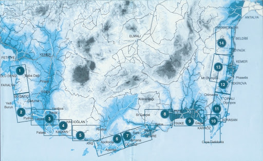
Maps of Lycia
Information about the Lukka from Penn State

Lycia Locations with modern map

Hellenistic maps f the lycia maps are coming tomorrow :)
Lycian Way Ultra Marathon
Lycian Way Marathon, which goes to the first Ultra Marathon in Turkey will be is an international sports organization based upon high temptation. The 250 km long, up to 6 days (consisting now of six rounds, one round per day to run), and is almost half of the historic, 509-kilometer road Lycia, one of the main objectives of the ultra-marathon on the earth through the agency its characteristics.
Application
LYM 2010’s enrollment fee is 1000 Euro (+300 Euro security deposit) per person. Team members pay the same price per person. For example, if a team of three people wish to enroll the fee is 3000 EU. The 300€ security deposit will be refunded to those who finish the marathon.
Conditions of Participation
•The Lycian Way Marathon is going to take place in a roughness environment, harboring many handicaps. The participants ought to carry both their necessary and obligatory equipments in their backpacks. The participants will be accommodated in tents in the main camping area, in which they are going to be able to reach medical services (to keep them healthy) and also hot water (helping them to cook easier). In the checkpoints, drinking water and medical care (in case of emergencies) are going to be available for them.
Route & Advices
•The marathon is going to be run on a section of the Lycian Way, between 220 and 250 kilometers. The whole Lycian Way is 509 kilometers long between Fethiye and Antalya. The actual details about the racecourse and the road-map will be given to the participants just before the race starts.
•The route contains acclivities and declivities between sea level and mountains, has 800 meters altitude,it has sandy, stony-rocky paths, dirt roads.
•Partially existing causeways,make running and even moving faster so hard.On such sections quick walking is recommended.
•The racecourse may cross over riverbeds. The depth of the water may differ from season to season.
Source
Kate Clow Biography

Name: Kate Clow (Kardelen Karli)
Born: Hitchin, Herts, England, 1947.
I've always been crazy about old roads. I like to look at a landscape and imagine past travellers; who they were, where they were going, what they were trading. Turkey has so many thousands of years of history, practically every mountain has a well-used pass, practically every river a ford or a bridge. And in the forests or along the valley sides, there are still traces of the roads that linked them.
Education: English High Schools (to 1965). Technical computer training, then Open University Accounting and Marketing Diplomas (to 1988). Istanbul University International Management Diploma (to 1992). Employment: Computer programmer, British Aerospace (to 1967);
Production and computer management, Unwins Printing Group (to 1974);
Computer manager for Bank of Boston subsidiary, London (to 1985);
Sales account executive (technical); worked on major government and private accounts, Wang Computers, London (to 1989);
Sales account executive (technical), World Bank contracts, Transcom (a Wang subsidiary), Istanbul and Ankara (to 1993). Source
Lycian Tour Complete kmz


To have seen and read about the walk as one of 10 large migrations of the world, I was expecting something else. Without doubt it has some high points, the ruins of Olympus, Kekova, and kayaking on the sunken city, and the coastal sections on foot were very good, but do not offer mountains of dramatic peaks, often seem a little boring, with the vegetation very shaggy in many parts. That is, it was not unpleasant, and the Turkish people were very friendly and hospitable, with hiking opportunities during the trip without a guide to the villages and cities allows us to more rural life in Turkey seen as expected. Not the classic Trek I expected, but still quite a pleasant journey.
Friday, September 10, 2010
Lycian Way Google Earth Trekking Flights
Spend a week enjoying a challenging hike following Turkey's long-distance coastal path. Walk inland to the summit of Mt limestone. Olympos, climbing to the summit at 2388 m for the great views, before returning to the coast for walks in the farming village Adrasan and along the cliffs and coves to Cape Gelidonya.
If you have Google Earth installed on your computer, you can use the KMZ file and watch the whole tour in full screen view
Sunday, September 5, 2010
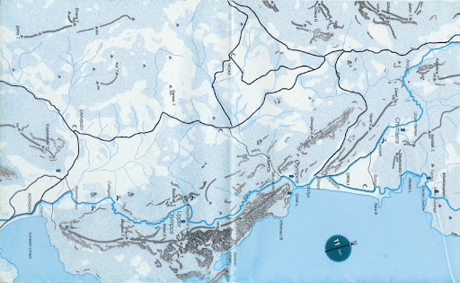
New Lycian Way Maps
Hey there are new Liycan Way maps in there. http://picasaweb.google.com/likyatatil/LikyaYoluHaritas#
Subscribe to:
Posts (Atom)